
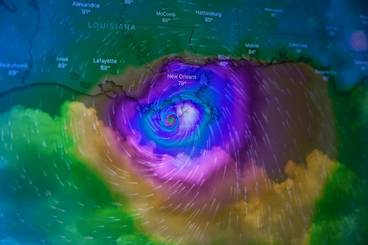
Erin Rapidly Intensifies into a Monstrous Category 5 Hurricane
Meteorologists and coastal residents are facing a nightmare scenario as Hurricane Erin has undergone a terrifyingly rapid intensification, officially becoming a monstrous Category 5 hurricane with sustained winds exceeding 160 mph. This escalation, observed in the open Atlantic in the early weeks of the 2025 hurricane season, serves as a stark and sobering reminder of the raw, destructive power these systems can unleash. The transformation of Erin into a Category 5 hurricane is a textbook case of rapid intensification, a phenomenon that poses one of the greatest forecasting challenges and public safety threats.
The process began when Erin, then a disorganized tropical storm, encountered a perfect confluence of atmospheric conditions. Sea surface temperatures were significantly above average, acting as a massive energy source. Wind shear, which typically inhibits storm development, was virtually nonexistent, allowing the hurricane’s structure to tighten and organize unimpeded. Furthermore, the atmosphere was ripe with moisture, providing ample fuel for the powerful thunderstorms that form the hurricane’s core. In less than 24 hours, Erin’s central pressure plummeted, and its wind speeds increased by an astonishing 65 mph, catapulting it into the highest echelon of storm classification. This explosive growth left little time for traditional preparation timelines, highlighting a critical vulnerability in disaster response.
Understanding the mechanics behind this process is crucial. A hurricane’s strength is directly tied to its ability to efficiently extract heat from the ocean and convert it into wind energy. In Erin’s case, the warm ocean waters extended to a significant depth, preventing any cooler water from upwelling and weakening the storm as it moved. The heat engine was able to run at maximum efficiency, creating a perfectly symmetrical and terrifyingly powerful cyclone with a clear, well-defined eye. The energy contained within a system of this magnitude is almost incomprehensible, exceeding the total energy released by multiple atomic bombs every second.
The primary danger of a storm like Erin lies in its trifecta of threats: catastrophic winds, devastating storm surge, and torrential rainfall. Winds within a Category 5 hurricane are capable of total devastation. Well-built homes can have their roofs torn off and walls collapsed. High-rise buildings are susceptible to severe damage, particularly on higher floors. Fallen trees and power poles will render vast regions uninhabitable for weeks, if not months, cutting off communities from essential services and emergency aid. The sheer force can turn unsecured objects into deadly projectiles, making evacuation the only safe option for those in the projected path.
Perhaps the greatest killer in hurricanes is not the wind, but the water. Storm surge, the abnormal rise of water generated by a storm’s winds, is expected to be life-threatening. Erin’s powerful winds are pushing a massive wall of water toward shorelines. This surge can penetrate miles inland, inundating coastal communities with depths exceeding 15 to 20 feet in some areas. The surge can easily sweep away buildings, erode foundations, and cause unprecedented flooding. Following the surge, relentless rainfall measured in feet, not inches, will lead to widespread inland flooding, overwhelming drainage systems and causing rivers to swell far beyond their banks. This compound flooding event creates a cascading disaster that is difficult to escape and even more challenging to recover from.
For those in the path of such a storm, preparedness is not a suggestion; it is a matter of survival. If an evacuation order is issued for your area, you must leave immediately. Do not focus on the exact category or the precise track of the eye; the impacts of a storm this large will be felt hundreds of miles from the center. Have a pre-determined evacuation plan that includes a destination inland, multiple routes to get there, and a full tank of gas. For those who cannot evacuate, securing your home is paramount. Board up windows with hurricane shutters or plywood, bring all outdoor furniture and decorations inside, and identify a small, interior, windowless room on the lowest level of your home to use as a safe room during the storm’s passage.
Your emergency kit should be stocked and ready. It must include at least three days’ worth of non-perishable food and water (one gallon per person per day), a first-aid kit, prescription medications, a battery-powered or hand-crank NOAA weather radio, flashlights with extra batteries, important documents in a waterproof container, and cash. Do not underestimate the psychological toll of a major disaster; include comfort items like books, games, or a deck of cards to help pass the time without power. Stay informed by monitoring updates from official sources like the National Hurricane Center and your local emergency management office. Heed their warnings and advice without hesitation.
The rapid intensification displayed by Hurricane Erin is a troubling trend that scientists have been observing and warning about for years. As ocean temperatures continue to rise due to climate change, the potential fuel available for hurricanes increases. This creates an environment more conducive to these rapid, explosive strengthening events, making storms more dangerous and less predictable. The case of Erin in 2025 is a dire data point in this growing body of evidence, underscoring the urgent need for continued research, improved forecasting models, resilient infrastructure, and comprehensive public education to mitigate the impacts of these climate-fueled super storms in the future.


 FTC Probe Blocked: Judge Halts Liberal Media Watchdog Investigation